

vTools Survey - GPS Mapping
All map data files management, field surveying and mapping with GPS
App info


Advertisement
App description
Android App Analysis and Review: vTools Survey - GPS Mapping, Developed by vTools Apps. Listed in Tools Category. Current Version Is 8.5.8, Updated On 24/06/2025 . According to users reviews on Google Play: vTools Survey - GPS Mapping. Achieved Over 30 thousand Installs. vTools Survey - GPS Mapping Currently Has 76 Reviews, Average Rating 4.5 Stars
Function of application:- All map data files management, field surveying and mapping with GPS
- Positioning, current position, practical view angle in the field. Help identify better directions.
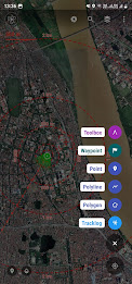
- Allows users to directly create objects (Points, Lines, Polygons, Coordinate Waypoints, Tracklog routes).
- Allows rapid measurement of the area and length of objects in the field.
- Users can simultaneously create Tracklog, Point, Line, and Polygon at the same time while moving. Tracklog mode allows running in the background.
- Support to save attribute information and images in the field.
- Users can define forms fields to collect. And share quickly to the whole group via QR code or export to file.
- Find for waypoint, enter a list of waypoints from data TEXT(*.txt), Excel (*.xls, *.xlsx), CSV (*.csv) Excel and convert point coordinates directly on the device.
- Allow to enter the list of points to check by hand (For example, it is necessary to check the location of the extract of the red book).
- Support directly opening common data such as Excel, GPS/GPX, KML/KMZ, GeoJSON, AutoCAD DXF, MicroStation DGN, ESRI Shapefile SHP, MapInfo TAB, gCadas GTP, GeoTIFF, JPG, PNG
- Support export data to GPX, KML, GeoJSON, Excel, AutoCAD DXF, MapInfo TAB, Shapefile SHP format and share via Email, Drive, Zalo, Facebook etc.
- Fully support the VN 2000 projection system of the local and nationwide of Vietnam.
- Support more than 5000 projection systems of other countries and territories in the world.
- Support for old projection systems like Hanoi 1972 (HN 72).
- Support numerical compass feature
- Support reading offline map data MBTiles and intelligent management of data layers.
- Support with simple MBTiles convert tool on Desktop, help to view properties directly from MBTiles layer.
- Support conversion of TCVN3, VNI encoding for Vietnamese font in viewing attribute information.
- Support field photography, save location, shooting direction on images and Exif information, GeoTag
- Allow users to download Google, MapBox, Bing, ESRI, OSM directly on the computer for offline use.
- Support web map service TMS and WMS.
- The feature allows users to directly find and use Landsat 8 satellite image data (16-day update cycle) and Sentinel 2 (5-day update cycle) from the image database.
- Location view feature with 3D perspective with global elevation digital model.
If you need assistance please contact us at the following information:
Facebook: https://www.facebook.com/vToolsForMapInfo
Email: [email protected]
Phone (Zalo, Telegram): (+84) 96 990 4596
Website: https://apps.vtools.xyz
Youtube: https://www.youtube.com/c/vTools/playlists
All Rights Reserved. Copyright © vTools Apps
We are currently offering version 8.5.8. This is our latest, most optimized version. It is suitable for many different devices. Free download directly apk from the Google Play Store or other versions we're hosting. Moreover, you can download without registration and no login required.
We have more than 2000+ available devices for Samsung, Xiaomi, Huawei, Oppo, Vivo, Motorola, LG, Google, OnePlus, Sony, Tablet ... with so many options, it’s easy for you to choose games or software that fit your device.
It can come in handy if there are any country restrictions or any restrictions from the side of your device on the Google App Store.
Rate and review on Google Play store
Total number of installs (*estimated)
Estimation of total number of installs on Google Play, Approximated from number of ratings and install bounds achieved on Google Play.You may also like these apps


Discover Apps

- Psychic Horoscope, AI Ancestry

- Universal Smart TV Remote Ctrl

- PLAUD

- AI Cleaner - Phone Cleaner

- AirTag Scan, Detect & Tracker

- Alarm Clock

- Gallery: Photo Gallery, Album

- Music Downloader MP3 Download

- All Document Viewer Doc Reader

- Photo Recovery - File Recovery

- Cleaner Antivirus VPN Cleaner

- AAWireless for Android Auto™


Recent Comments
Phong Pham Hong
Greate app for survey on field site. Thank author 👍
Ahmed mo Seid
Best ever app
SNRM2 Project
Apps rat hay, cam on tac gia
Thiện Đức
Good app
Thái Vũ Văn
Với kinh nghiệm 10 năm review sản phẩm dòng thu thập thông tin dạng geoapp thì đây là app tôi đánh giá hoàn hảo nhất. App không chỉ thay thế cho GPS truyền thống, mà còn hỗ trợ các dạng bản đồ khác nhau .tab .shp .dgn .dxf .... Đọc cả dữ liệu không gian và thuộc tính. Dân địa chính, lâm nghiệp, tư vấn bất động sản nên dùng tư vấn cho khách cứ gọi là promax luôn cả lan bàn hướng. Các đơn vị Lâm nghiệp đang đã đánh giá rất cao về hỗ trợ, update thường xuyên chức năng mới theo góp ý của người dùng