

Russian Topo Maps Pro
Worldwide Topographic Maps - OFFLINE USAGE !
App info


App description
Android App Analysis and Review: Russian Topo Maps Pro, Developed by ATLOGIS Geoinformatics GmbH & Co. KG. Listed in Maps & navigation Category. Current Version Is 7.8.1, Updated On 21/05/2025 . According to users reviews on Google Play: Russian Topo Maps Pro. Achieved Over 79 thousand Installs. Russian Topo Maps Pro Currently Has 8 thousand Reviews, Average Rating 5.0 Stars
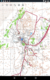
Offroad navigation app with worldwide topographic maps (mainly Russian general staff maps). There are also many other map layers with up-to-date and detailed maps or aerial photos.Even though most of the Russian maps date back to the 1980s, they are still among the best topo maps available for many regions in Africa and Asia, especially if you are looking for remote tracks or old infrastructure. All maps are also labelled in English.
Map data can be downloaded so that the application can also be used without internet reception. No user data is collected by the app!
Selectable map layers (worldwide):
• Topo maps (worldwide coverage 1:100,000 - 1:200,000) Russian General Staff maps - Genshtab
• GGC Gosgiscentr Topo maps Russia 1:25,000 - 1:200,000
• ROSREESTR The Federal Service for State Registration, Cadastre and Cartography (only Russia. Up-to-date and very detailed)
• Yandex Maps: Satellite images, road map. (Online use only!)
• Openstreetmap: excellent maps with different styles as well as shading & contour lines): OSM Topo, OSM Cycle Map (especially for cyclists), OSM Outdoors (for hikers), OSM Landscape
• Google Maps: Satellite images, road and terrain maps. (Online use only!)
• Bing Maps: Satellite images and street map. (Online use only !)
• ESRI Maps: Satellite images, street and terrain map.
All maps can be created as overlays and compared with each other using a transparency slider.
Switchable overlays (worldwide):
• Hillshading
• 20m contour lines
- OpenSeaMap
This app offers all functions for comprehensive outdoor navigation:
• Download of maps for OFFLINE operation (except Google, Bing & Yandex Maps)
• Create waypoints
• GoTo waypoint navigation
• Create and navigate routes (with automatic route calculation based on OpenStreetMaps)
• Track recording (evaluation with speed and altitude profile)
• Freely configurable data fields in the map view (e.g. speed, altitude)
• Tripmaster with fields for daily kilometres, average, distance, compass, etc.
• GPX/KML/KMZ import export
• Search function (locations, POIs, street names)
• Waypoint/track sharing (via e-mail, WhatsApp, ...)
• Measurement of paths and areas
• UMTS/MGRS GRID
Other maps can be imported in common formats:
• GeoPDF
• GeoTiff
• MBTiles
• Ozi (Oziexplorer OZF2 & OZF3)
• Online map services can be integrated as WMS servers or XYZ tile servers.
• OpenStreetMap maps can also be downloaded country by country in space-saving vector format!
For questions please contact [email protected]
What's New
・Support for shapes: Display shapes from shape, gejson or kml/kmz files
・Android 15 support
・Bug fixes & Improvements
・Android 15 support
・Bug fixes & Improvements
Rate and review on Google Play store
Total number of ratings
Total number of active users rated for: Russian Topo Maps ProTotal number of installs (*estimated)
Estimation of total number of installs on Google Play, Approximated from number of ratings and install bounds achieved on Google Play.You may also like these apps


Discover Apps


Popular Apps

- Phone Tracker By Number in US
- ChargePoint

- DiDi Rider: Affordable rides

- Satellite View - Maps - Radar

- GPS Location Tracker Phone App

- Radar GO-X: HUD, GPS, Maps

- GPS, Voice Navigation live Map

- GPS Location Tracker for Phone

- Speedometer - Odometer App

- GPS Satellite Live Earth Map

- Live Earth Map - World Map 3D

- Live Earth Map Satellite View


Recent Comments
Sean Neves
Great mapping app. Very useful layers and 3 separate satellite image databases. Has some very interesting base maps of remote areas.
Alejandro Cesar
With this app, I can save tracks in GPX files, allowing me to share the track with other devices or friends. I can even draw tracks on a map and follow.
Alexander Nikitin
I am using it for my backpacking trips in Siberia for a number of years. It is very useful for navigating in unknown areas especially if you did not prepare a trip plan in advance and have no GPS cooddinates for key points. Just do not forget to download maps for the area of interest.
Brian Cuttell
Previously 5 star. Excellent ability to download osm maps. Recently the app has developed a bug whereby the map reverts to the base Soviet map when app is restarted very annoying. Started to use alternative map apps. Shame
Unaligned Coder
Unfortunately location doesn't work at all. Keeps placing me in the Moscow area even though I am in Almaty. Says it took it from the network, which can't be. Besides GPS in the phone works fine, permission is allowed, so there is a basic problem with the app.
Marius Lüdi
top map application and outstanding service desk. I use the pro version to download different Map layers (opentopo, esri Satellite) to navigate through remote terrain. I did not see any better App for Offroading until now. Thank you
Ulf Persson
In spite of odd name a good usefull map program. Please add a distance "timer" very useful when jogging or cycling. Forex 3 km and then you know to trurn back.. Some more overlays would be cool, what about historical sites.
John Venkov
best all in one topographical and general map that allows you to download all kinds of maps and overlays with them at the zoom level you want. can't recommend it enough!